Origins: How the Map Was Invented
The origins of the map run from Babylonian clay tablets to Ptolemy's projection system to the German cartographer who accidentally named an entire continent America.
Mapping appears, from the outside, to be the obvious thing to do once you understand that you exist in a physical world with other places in it. Draw where things are. Note the distances. Pass the information on. It is so apparently obvious that most people assume humans have been making maps since prehistory - crude scratches on cave walls, rough plans scratched in dirt.
The reality is stranger. True maps - documents that represent geographical relationships with consistent orientation, approximate scale, and the intention of conveying spatial information to someone who has not been there - took a very long time to develop, were repeatedly lost and rediscovered, were dismissed and then canonized by institutions that had not made them, and were used to name an entire continent after the wrong person.
The history of the map is less a straight line from primitive to sophisticated than it is a series of brilliant individual solutions to the problem of representing the world on a flat surface, separated by centuries in which those solutions were forgotten.
What counts as a map
The definition matters. A painting of animals in a landscape is not a map. A list of place names with distances between them - a Roman road itinerary, a medieval pilgrim's guide - tells you sequence, not direction. What we are looking for is a document that represents the spatial relationships between locations, with enough internal consistency that a viewer can understand not just what exists but where it exists in relation to everything else.
By that definition, the earliest credible candidate is a wall painting.
Catalhoyuk and the first possible map
The Neolithic settlement of Catalhoyuk in south-central Turkey was occupied from roughly 7500 to 5700 BCE. Among its wall paintings, archaeologists in the 1960s identified one that may depict a plan view of the settlement itself, with a twin-peaked volcano in the background - probably Hasan Dag, which erupted during the settlement's occupation period.
If correct, it would be the oldest known map by several thousand years. The debate remains active: some see a town plan with a volcano; others see a decorative pattern that has been over-interpreted. What is not disputed is that the intent - if it was a map - was entirely local, representing only what could be seen from the settlement.
Egypt: the first map with a purpose
The earliest surviving document that functions unambiguously as a map is the Turin Papyrus, dating to around 1150 BCE. Now held in the Egyptian Museum in Turin, it was drawn by a scribe named Amennakhte during an expedition to the Wadi Hammamat quarrying region in the Eastern Desert of Nubia, under Ramesses IV.
The papyrus shows a section of the wadi, the routes between it and the Nile, the location of gold mines and stone quarries, and the Egyptian settlements along the route. It uses different colors to distinguish rock types. It includes what appear to be distance notations. It is, in any meaningful sense, a geological and route map made for a practical purpose - organizing a quarrying expedition in difficult terrain.
This is significant: the first clearly functioning map in the historical record was made for extractive industry, not cosmology. It was a tool, not a statement about the universe.
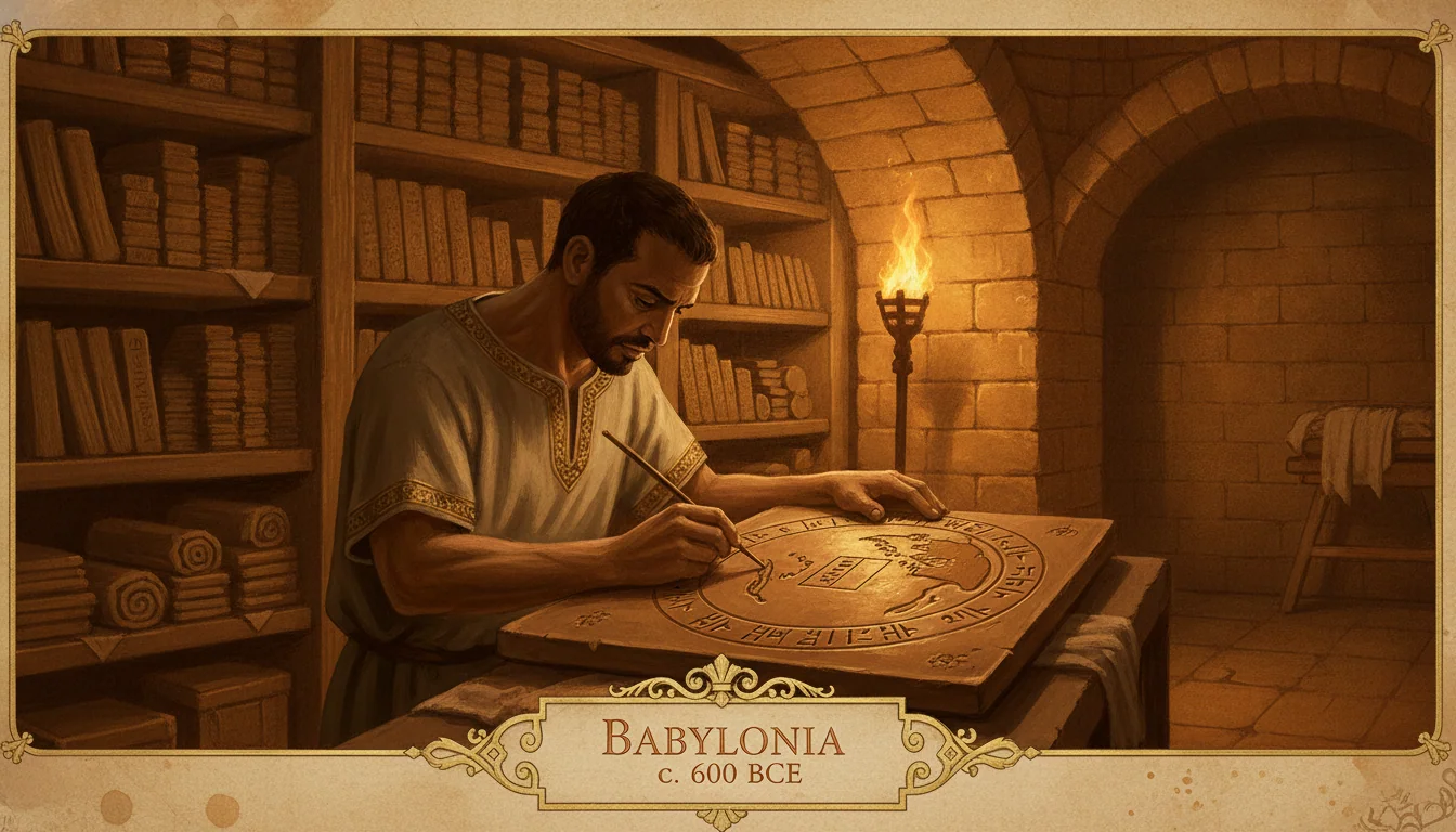
Babylon and the first world map
Roughly five centuries after the Turin Papyrus, a Babylonian scribe inscribed a very different kind of map onto a clay tablet. The Imago Mundi - dated to around 600 BCE and now in the British Museum - is the first surviving attempt to represent not a local area but the entire known world.
Its geography is centered on Babylon, which sits at the middle of a circular flat disc. The Euphrates runs through it. Neighboring regions - Assyria, Urartu, a swamp, a city the text identifies as "the city of Der" - are represented as labeled ovals surrounding the center. A circular band of ocean (marratu) surrounds the disc. Beyond the ocean, triangular shapes extending outward are labeled as distant or mythological regions, described in accompanying cuneiform text as places of supernatural phenomena.
The Imago Mundi is not a useful navigational tool. It is not geographically accurate. What it is, definitively, is a cosmological argument: the world has a center (Babylon), a structure (land surrounded by sea), and edges where the known gives way to the mythological. It represents the world as the Babylonians understood it to be organized, not as an accurate spatial record of it.
As an intellectual document, it is foundational. It established the conceptual habit, which would persist for two thousand years in various traditions, of placing the map-maker's civilization at the center of the known world.
The Greeks: measurement, projection, and the spherical earth
The Greek contribution to the history of the map was the recognition, developed across several centuries, that the earth is spherical and that this fact has profound consequences for representing it on a flat surface.
Anaximander of Miletus, working around 550 BCE, is credited by later Greek writers with producing the first systematic map of the known world - a circular disc showing the lands around the Mediterranean with ocean surrounding them. The original is lost; only the description survives.
Eratosthenes, the librarian of the great library at Alexandria, went further in the 3rd century BCE. He calculated the circumference of the earth by measuring the angle of the sun's shadow at Alexandria and at Syene (modern Aswan) simultaneously at noon on the summer solstice. His estimate of roughly 40,000 kilometers was remarkably close to the actual circumference. He used this result to create a world map with a grid system that placed geographical features relative to their calculated latitude and longitude. He introduced the word "geography." He died, according to tradition, of voluntary starvation after losing his sight, unwilling to be unable to read.
Ptolemy: the work that shaped five centuries
The most consequential single contribution to the history of cartography was made by Claudius Ptolemy, a Greek-Egyptian scholar working in Alexandria in the 2nd century CE. His Geographia is not itself a map: it is a set of instructions for making maps, combined with a list of coordinates (latitude and longitude) for approximately 8,000 named places across the known world, from Ireland to Southeast Asia.
Ptolemy described two projection methods and acknowledged the distortion any flat representation necessarily introduces. His coordinates were imperfect - he compressed Asia, misplaced several Mediterranean points, and had vague information about Africa's interior - but the framework was unprecedented in scope and internal consistency.
The Geographia was lost to Western Europe when the Western Roman Empire collapsed. It survived in Byzantine libraries, was translated into Arabic, and reached European scholars around 1406-1415. It arrived just in time: within decades, the printing press let Ptolemy's framework circulate in thousands of copies, and European cartographers used it as their foundation at precisely the moment they were beginning to explore the world.
The medieval interval: T-O maps and Al-Idrisi
Between Ptolemy's original work and its recovery, two very different cartographic traditions developed.
In Christian Europe, the dominant form was the mappa mundi - a circular map with east at the top, Jerusalem at the center, and the three known continents arranged around a T shape. The Hereford Mappa Mundi (c. 1300) is the most famous surviving example: an extraordinary document but not a navigation tool. It is a theological diagram organized according to Christian cosmology, not a spatial record.
In the Islamic world, Mohammed al-Idrisi produced something far more useful. Working in Sicily for the Norman King Roger II, al-Idrisi spent fifteen years gathering geographical information from travelers and Arabic tradition. His Tabula Rogeriana, completed in 1154, was the most accurate world map of the medieval period. Notably, it displays south at the top - an Islamic cartographic convention - which makes it look upside down to modern readers but is no less accurate than north-up orientation.
Naming an entire continent after the wrong person
In 1507, the German cartographer Martin Waldseemüller produced the first map to show the Americas as a separate landmass and labeled it "America" - after Amerigo Vespucci, the Florentine navigator whose accounts most clearly argued the western hemisphere was a new continent rather than an extension of Asia. One copy of the 1507 map survives, purchased by the Library of Congress from a German castle library in 2003 for ten million dollars.
Waldseemüller later expressed doubt and removed the name from subsequent editions. It was too late. The name had already been copied into dozens of other maps. Christopher Columbus, who reached the Caribbean first and died in 1506 still believing he had reached Asia, received an island chain rather than a continent.
What the map makes possible
The history of cartography is inseparable from the history of power. The ability to represent space accurately - to convey not just "there are mountains to the east" but "the mountains are here, the pass is here, and the distance is approximately this far" - is the ability to plan, to tax, to conquer, and to trade at scale. Every empire that lasted more than a generation developed cartographic tools appropriate to its administrative reach.
The Ptolemaic framework mattered not because it was perfectly accurate but because it provided a consistent system that could be updated and shared. It gave European cartographers a foundation at exactly the moment they needed one.
The map was not invented once. It was reinvented, repeatedly, by people working on different problems in different places - an Egyptian scribe organizing a mining expedition, a Babylonian priest explaining the cosmos, a Greek mathematician calculating the earth's size, a German printer deciding what to call a new continent. None of them were making the map. Each was solving their own problem. The map accumulated out of the solutions.
That is how most of the fundamental human tools actually work.
For related origins of navigation and discovery, see Origins: How the Compass Was Invented. For the Alexandrian world where Ptolemy worked, see Visiting Ptolemaic Alexandria in 250 BC.
Quick Answers
Common questions about this topic
What is the oldest known map?
The Turin Papyrus, dating to around 1150 BCE, is the oldest surviving map with a clear geographical purpose - it shows gold mines and quarries in the Wadi Hammamat region of Nubia, drawn by an Egyptian scribe under Ramesses IV. Earlier candidates exist, including a wall painting at the Neolithic site of Catalhoyuk in Turkey (around 6200 BCE) that may depict a settlement plan with a volcano, but its status as a true map is disputed by archaeologists.
What was the Babylonian Map of the World?
The Imago Mundi is a clay tablet dating to around 600 BCE, now in the British Museum. It shows Babylon at the center of a flat disc surrounded by a circular ocean (marratu), with neighboring regions labeled as blobs around it. Mythological islands appear at the edges. It is the earliest surviving document that attempts to represent the entire known world, not just a local area.
Why was Ptolemy's Geography so influential?
Claudius Ptolemy, a Greek-Egyptian scholar working in Alexandria around 150 CE, wrote instructions for projecting a spherical earth onto a flat surface and provided coordinates for roughly 8,000 named places. His work was lost to Western Europe after the fall of Rome, preserved in the Byzantine world, and recovered by European scholars around 1406. When the printing press arrived, Ptolemy's framework became the foundation for early modern European cartography - including the maps produced during the age of exploration.
Who first named America on a map?
Martin Waldseemüller, a German cartographer, produced the first map to label the landmass in the western hemisphere as 'America' in 1507. He named it after Amerigo Vespucci, the Florentine navigator who had published accounts arguing the New World was a separate continent rather than an eastern extension of Asia. Waldseemüller later expressed doubt and removed the name from subsequent editions, but the 1507 map - one original copy survives, now in the Library of Congress - had already circulated widely enough that the name stuck.
Ask the Inventors Themselves
Chat with the people who were there when familiar things began.
Trace It to the Source